Before you begin you need to find the latitude and longitude coordinates for some points around your location:
Northwest corner of the plot.
Southeast corner of the plot.
Approximate center of the plot.
The easiest way to do this is with Google Earth. If you do not already have it, download and install it before proceeding.
Open up Google Earth.
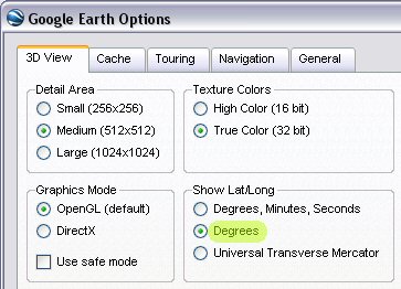
Go to Tools > Options.
Under Show Lat/Long change "Degrees, Minutes, Seconds" to "Degrees" and click OK. This gives the coordinates in decimal degrees.
Find the location you want to use. You can do this by panning and zooming the image or by entering a city/address in the "Fly to" field in the upper left.
Once you have your location in view double click the N on the compass in the upper right. This rotates the image to ensure north is facing up.
Move your mouse to the point you want to use as the northwest corner of your plot. Give plenty of room for the north and west boundaries of your course. If there are land features visible outside the course you may want to include these too.
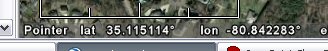
Write down the latitude and longitude shown in the lower left portion of the screen including any negative signs. Negative latitude indicates the Southern Hemisphere and negative longitude indicates the Western Hemisphere.
Repeat steps 6 and 7 for southeast corner and the approximate center of the plot.